Key Takeaways
- Florida's Healthy Beaches program tests for enterococci bacteria. Two results over 70 per 100 mL in a row trigger an advisory.
- Bacteria results reflect the day of sampling, so advisories can lag several days behind a storm.
- Check FWC's daily red tide sample map, updated at 5 p.m., and its Friday status report before a Gulf coast swim.
- Double red means the water is closed. The absence of a flag does not mean the water is safe.
- Beach flags warn about surf in general, so check the National Weather Service rip current risk too.
Last checked: 23 September 2026. Advisories, red tide conditions and surf change daily, so use the official links below on the day you swim.
A Florida beach can look perfect and still be a poor swim. Three things usually decide it: bacteria, red tide and surf. Each has its own official source. Here's where to look and how to read what you find.
Bacteria: the Florida Healthy Beaches program
The Florida Department of Health samples coastal beaches for enterococci, bacteria that live in the guts of people and animals. The department uses them because they track swimming-related stomach illness better than other indicator bacteria. They also survive longer in salt water. The department lists the likely sources as stormwater runoff, pets and wildlife, and human sewage.
Results fall into three bands, per 100 milliliters of seawater:
- Good: 0 to 35 enterococci
- Moderate: 36 to 70
- Poor: 71 or more
How advisories work
One high result doesn't trigger an advisory on its own. If a sample exceeds 70 colony-forming units per 100 mL and a resample also exceeds it, an advisory is issued for that sampling site. It stays in place until bacteria levels fall back below the health standard.
Expect a lag. In September 2026, DOH-Sarasota issued an advisory for Brohard Beach on a Friday, based on tests completed that Monday. It lifted the advisory the next day after a clean retest. A result tells you what the water was like on sample day, not today.
The program's own history says funding changes in 2011 moved sampling to every two weeks. They also paused sampling in northern counties from November through February. Check your county's page for the current schedule.
Where to look
- The statewide Healthy Beaches page has an interactive map and links to each participating county's results.
- County health departments post advisories and lifts as news releases on their own sites.
- An advisory covers one sampling site, not the whole coast. Find the site nearest the spot you'll swim.
Red tide: what it is and how to read FWC's map
In Florida, red tide usually means a bloom of Karenia brevis, a microscopic alga. It's in the water year-round at low background levels. The Florida Fish and Wildlife Conservation Commission (FWC) says blooms happen in the Gulf almost every year, usually in late summer or early fall.
They're most common between Clearwater and Sanibel Island. That stretch includes Clearwater Beach, Fort De Soto, Manatee Public Beach, Lido Beach, Siesta Beach and Sanibel Lighthouse Beach. Blooms are less common on the Atlantic coast, but they do happen.
K. brevis produces toxins called brevetoxins. Wind and waves break the cells open and release toxin into the air and water.
Symptoms
The Department of Health lists these effects:
- Coughing, sneezing and irritated eyes, nose and throat, even in people without breathing problems.
- Worse reactions in people with asthma, emphysema, bronchitis or other chronic lung disease.
- Skin irritation, rashes, burning and sore eyes if you swim in it.
Its advice is clear: don't swim in or around red tide. If you touch it, wash off with soap and water. Air-conditioned rooms help with breathing symptoms. If symptoms don't improve, see a doctor or call the Florida Poison Information Center at 800-222-1222. Don't harvest or eat distressed or dead fish from a bloom area.
Reading the FWC status map
FWC's Red Tide Current Status page has two tools:
- Daily sample map. It shows the last eight days of samples and updates daily at 5 p.m. Click a dot for its details.
- Status report. It's published on Friday afternoons, with extra updates on Wednesdays when available. It covers the Southwest, Northwest and East coasts and notes fish kills and breathing irritation.
Dot colors follow the number of cells in each liter of water:
| Level | K. brevis cells per liter | Possible effects |
|---|---|---|
| Not present / background | 1,000 or fewer | None expected |
| Very low | Over 1,000 to 10,000 | Possible respiratory irritation |
| Low | Over 10,000 to 100,000 | Respiratory irritation, possible fish kills |
| Medium | Over 100,000 to 1,000,000 | Respiratory irritation, probable fish kills |
| High | Over 1,000,000 | As above, plus discolored water |
Look at the dots nearest your beach and check their dates. Each dot is one place at one time, and blooms move with wind and currents. For a forecast, FWC points to NOAA's Gulf Coast Harmful Algal Bloom Forecast. You can also hear the latest report by phone at 866-300-9399.
At the time of writing, FWC's September 18, 2026 report found K. brevis only at background levels, in one Sarasota County sample. No fish kills or breathing irritation were reported. The next report was due September 25.
Lakes and rivers have a different problem: blue-green algae. The Department of Health advises staying out of those blooms too, and points to the state's Protecting Florida Together water quality dashboard for current status.
Beach warning flags and rip currents
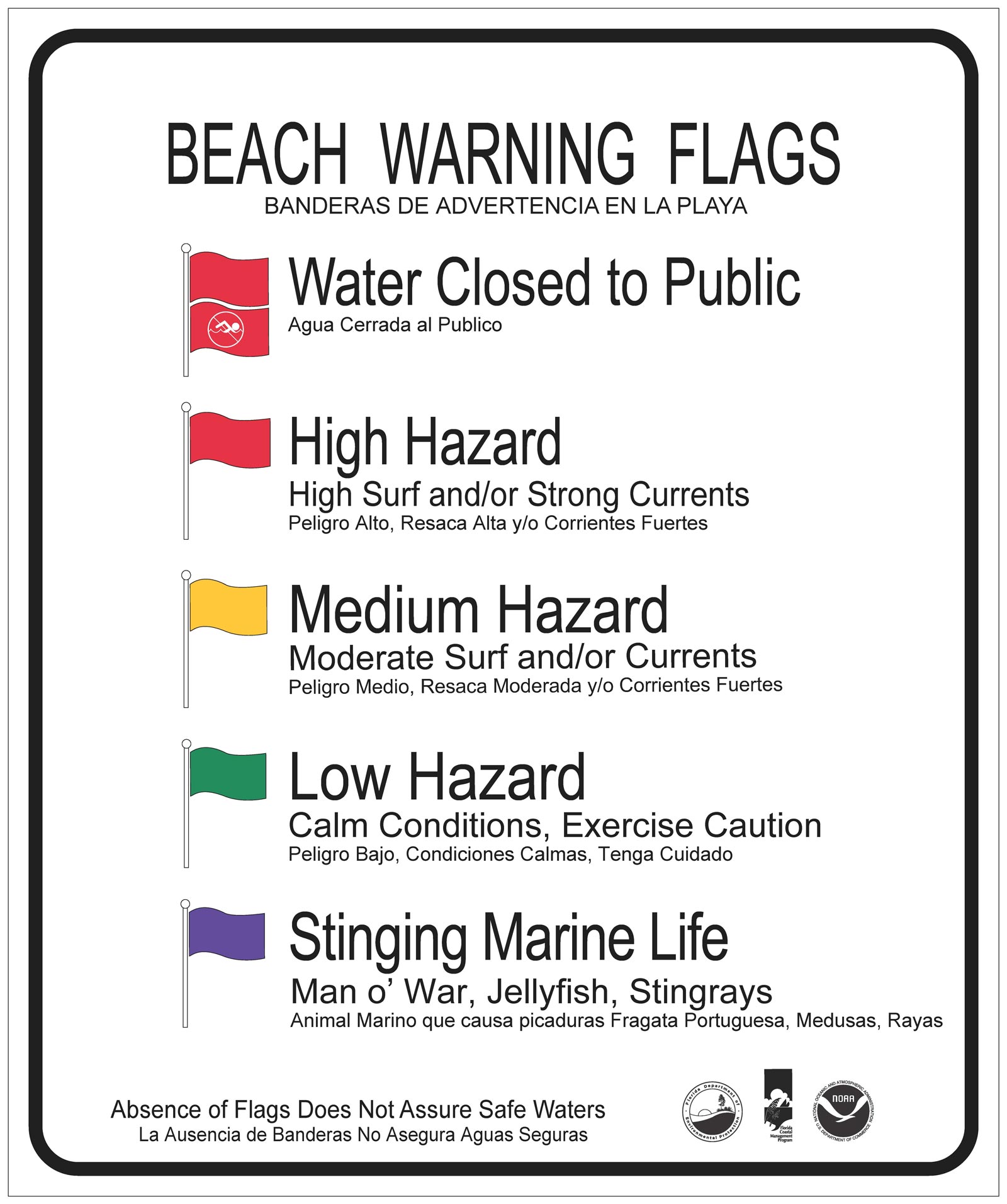
Florida has one uniform set of beach warning flags. Since 2005, state law has required public beaches that fly warning flags to use only the state program's flags. The official sign reads:
- Double red: water closed to the public.
- Red: high hazard. High surf and/or strong currents.
- Yellow: medium hazard. Moderate surf and/or currents.
- Green: low hazard. Calm conditions, exercise caution.
- Purple: stinging marine life, such as Portuguese man o' war, jellyfish and stingrays.
The Florida Department of Environmental Protection adds two cautions. Flags warn about surf in general, not rip currents specifically. And the absence of flags does not mean the water is safe.
Check the rip current risk
The National Weather Service issues Surf Zone Forecasts from its Jacksonville, Melbourne, Miami, Tampa and Tallahassee offices, and from Mobile, Alabama. They rate rip current risk at three levels:
- Low: risk is low, but life-threatening rips still often form near groins, jetties, reefs and piers.
- Moderate: life-threatening rips are possible in the surf zone.
- High: life-threatening rips are likely in the surf zone.
Pier beaches such as Cocoa Beach Pier and Daytona Beach's Main Street Pier deserve extra care on any day. The NWS also notes that rips often form on calm, sunny days.
If you're caught in a rip
The NWS advice:
- Relax. A rip pulls you out, not under.
- Don't swim straight at the shore. Swim along the beach until you're out of the pull, then angle back in.
- If you can't get in, face the shore and call or wave for help.
- Swim at lifeguarded beaches when you can. The NWS cites U.S. Lifesaving Association figures putting the chance of drowning at a lifeguarded beach at 1 in 18 million.
- On unguarded beaches, never swim alone, and leave someone ashore with a phone.
After heavy rain
Rain washes stormwater, and sometimes sewage, toward the beach. Florida's bacteria advisories follow lab results, so they often trail a storm by days.
- The Department of Health names stormwater runoff as a source of the bacteria it tests for.
- County health departments also post advisories after wastewater releases. In November 2025, DOH-Okaloosa issued one for Grass Lake and the entrance of Choctawhatchee Bay. It said the advisory would be lifted by press release once testing came back satisfactory.
- The Florida Department of Environmental Protection's Public Notice of Pollution site shows reported releases. You can subscribe to alerts for your area.
- The EPA's long-standing advice is simple: don't swim after a heavy rain, and don't swim near storm drains. The EPA also notes that states can issue precautionary advisories after heavy rain at beaches with a history of high bacteria.
A five-minute check before you swim
- Look up the nearest Healthy Beaches sampling site and any county advisory.
- On the Gulf coast, open FWC's daily sample map and the latest Friday report.
- Read the NWS surf zone forecast for rip current risk.
- Check the flag when you arrive, and talk to the lifeguard.
- Check the spot's live SwimScore on SwimPass for wind, waves and weather, and use it alongside the official advisories above.
Find more places to swim in Florida.
Sources
- Beach Water Quality (Florida Healthy Beaches) – Florida Department of Health
- Healthy Beaches interactive map – Florida Department of Health
- DOH-Sarasota Issues Water Quality Health Advisory for Brohard Beach (Sept. 11, 2026)
- DOH-Sarasota Lifts Water Quality Health Advisory (Sept. 12, 2026)
- Harmful Algal Blooms: red tide and blue-green algae – Florida Department of Health
- Red Tide Current Status – FWC
- Red Tide Daily Sample Map – FWC
- About Red Tides in Florida – FWC
- Gulf Coast Harmful Algal Bloom Forecast – NOAA
- Water Quality Status Dashboard – Protecting Florida Together
- Beach Warning Flag Program – Florida Department of Environmental Protection
- Beach warning flag sign – Florida Department of Environmental Protection
- Beach Warning Flag Specifications – Florida Department of Environmental Protection
- Rip Current Safety – National Weather Service
- Surviving a Rip – National Weather Service
- Surf Zone Forecasts – National Weather Service
- DOH-Okaloosa Issues Health Advisory for Grass Lake and the Entrance of Choctawhatchee Bay (Nov. 11, 2025)
- Public Notice of Pollution – Florida Department of Environmental Protection
- How to Safely Enjoy Your Beach: Don'ts – US EPA (archived)
- EPA's Beach Program: Safe to Swim or Stick to Shoreline? – US EPA